Cedar Rapids, IA Region on June 30, 2014
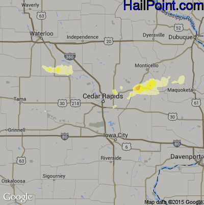
This hail map covers the Cedar Rapids, IA area from the evening of Sunday, June 29, 2014 to the early morning of Monday, June 30, 2014.
- Category:
Scattered
- Max. Hail Size:
1.5"
- Hail Reports: 1
- Impacts by Hail Size:
| Hail Size |
Population |
Housing |
Area (sq. mi.) |
| 0.50" - 0.99" | 109,962 | 48,361 | 842 |
| 1.00" - 1.49" | 3,621 | 1,610 | 49 |
$99.95
You can purchase this interactive hail map separately or as part of a subscription.
Buy Subscription
Try a Demo Hail Map | Hail Map Video Tutorial
All Subscription Plans Include
-
- Every Hail Map for that Region
- 5+ Years of Historical Hail Maps
- Full Screen Google Hail Map for iPhone, iPad, and Android
- Google Places Search – Find Businesses In Swath
- Unlimited Hail Map Searches
- Real Time Hail Alerts with Hail Maps
-
- Hail Impact Demographic Data
- Plot All Points of Interest ( ie: Dealerships, Home Depot's)
- Transparency Slider to Adjust Hail Overlay
- Edge to Edge Full Screen Maps
- Click on Rooftops & Get Exact Street Addresses
- Plot Address on Hail Map
- Print Map to Printer or PDF File
- Plot Your Location on Map
- Google Street View to Target Hail Damaged Homes