Austin, TX Region on May 10, 2013
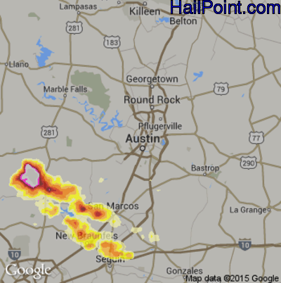
This hail map covers the Austin, TX area from the evening of Thursday, May 9, 2013 to the early morning of Friday, May 10, 2013.
- Category:
Scattered
- Max. Hail Size:
4"
- Hail Reports: 3
- Impacts by Hail Size:
| Hail Size |
Population |
Housing |
Area (sq. mi.) |
| 0.50" - 0.99" | 113,966 | 45,000 | 623 |
| 1.00" - 1.49" | 60,497 | 26,714 | 305 |
| 1.50" - 1.99" | 5,986 | 2,740 | 114 |
| 2.00" - 2.49" | 2,003 | 961 | 69 |
| 2.50" - 2.99" | 125 | 70 | 12 |
| 3.00" - 3.49" | 219 | 121 | 20 |
| 3.50" - 3.99" | 245 | 130 | 16 |
$99.95
You can purchase this interactive hail map separately or as part of a subscription.
Buy Subscription
Try a Demo Hail Map | Hail Map Video Tutorial
All Subscription Plans Include
-
- Every Hail Map for that Region
- 5+ Years of Historical Hail Maps
- Full Screen Google Hail Map for iPhone, iPad, and Android
- Google Places Search – Find Businesses In Swath
- Unlimited Hail Map Searches
- Real Time Hail Alerts with Hail Maps
-
- Hail Impact Demographic Data
- Plot All Points of Interest ( ie: Dealerships, Home Depot's)
- Transparency Slider to Adjust Hail Overlay
- Edge to Edge Full Screen Maps
- Click on Rooftops & Get Exact Street Addresses
- Plot Address on Hail Map
- Print Map to Printer or PDF File
- Plot Your Location on Map
- Google Street View to Target Hail Damaged Homes