Mahhattan, KS Region on June 11, 2022
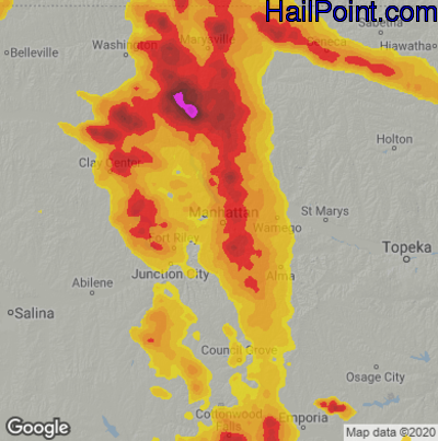
This hail map covers the Mahhattan, KS area from the afternoon of Saturday, June 11, 2022 to the early morning of Monday, June 13, 2022.
- Category:
Scattered
- Max. Hail Size:
3.25"
- Hail Reports: 14
- Impacts by Hail Size:
| Hail Size |
Population |
Housing |
Area (sq. mi.) |
| 0.50" - 0.99" | 82,048 | 34,364 | 2,020 |
| 1.00" - 1.49" | 55,591 | 23,353 | 1,473 |
| 1.50" - 1.99" | 6,511 | 2,771 | 493 |
| 2.00" - 2.49" | 807 | 387 | 74 |
| 2.50" - 2.99" | 188 | 91 | 31 |
$99.95
You can purchase this interactive hail map separately or as part of a subscription.
Buy Subscription
Try a Demo Hail Map | Hail Map Video Tutorial
All Subscription Plans Include
-
- Every Hail Map for that Region
- 5+ Years of Historical Hail Maps
- Full Screen Google Hail Map for iPhone, iPad, and Android
- Google Places Search – Find Businesses In Swath
- Unlimited Hail Map Searches
- Real Time Hail Alerts with Hail Maps
-
- Hail Impact Demographic Data
- Plot All Points of Interest ( ie: Dealerships, Home Depot's)
- Transparency Slider to Adjust Hail Overlay
- Edge to Edge Full Screen Maps
- Click on Rooftops & Get Exact Street Addresses
- Plot Address on Hail Map
- Print Map to Printer or PDF File
- Plot Your Location on Map
- Google Street View to Target Hail Damaged Homes