Mahhattan, KS Region on August 6, 2026
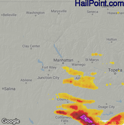
This hail map covers the Mahhattan, KS area from the evening of Wednesday, August 5, 2026 to the early morning of Thursday, August 6, 2026.
- Category:
Severe
- Max. Hail Size:
4.25"
- Hail Reports: 4
- Impacts by Hail Size:
| Hail Size |
Population |
Housing |
Area (sq. mi.) |
| 0.50" - 0.99" | 5,717 | 2,884 | 727 |
| 1.00" - 1.49" | 834 | 392 | 109 |
| 1.50" - 1.99" | 3,843 | 1,660 | 110 |
| 2.00" - 2.49" | 4,630 | 2,045 | 23 |
| 2.50" - 2.99" | 16,868 | 7,931 | 41 |
| 3.00" - 3.49" | 2,459 | 935 | 8 |
| 3.50" - 3.99" | 222 | 117 | 7 |
$99.95
You can purchase this interactive hail map separately or as part of a subscription.
Buy Subscription
Try a Demo Hail Map | Hail Map Video Tutorial
All Subscription Plans Include
-
- Every Hail Map for that Region
- 5+ Years of Historical Hail Maps
- Full Screen Google Hail Map for iPhone, iPad, and Android
- Google Places Search – Find Businesses In Swath
- Unlimited Hail Map Searches
- Real Time Hail Alerts with Hail Maps
-
- Hail Impact Demographic Data
- Plot All Points of Interest ( ie: Dealerships, Home Depot's)
- Transparency Slider to Adjust Hail Overlay
- Edge to Edge Full Screen Maps
- Click on Rooftops & Get Exact Street Addresses
- Plot Address on Hail Map
- Print Map to Printer or PDF File
- Plot Your Location on Map
- Google Street View to Target Hail Damaged Homes